Where are the darkest skies on Earth?
The question
The Bortle scale rates how dark a night sky is, from Class 1 (pristine — the Milky Way casts shadows) to Class 9 (inner-city). I wanted to answer a simple geometric question:
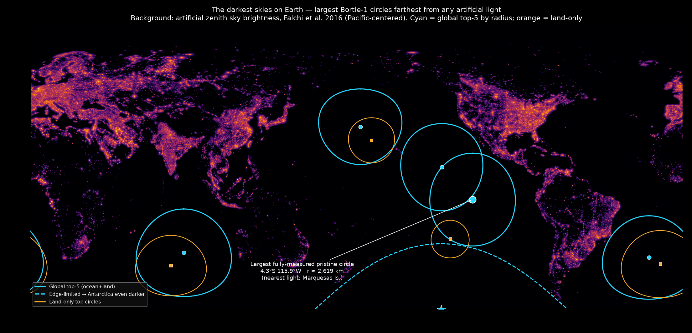
What is the point with a Bortle-1 sky that is farthest from any point with a Bortle > 1 sky?
In other words: where on Earth can you stand under a perfect sky and be as far as possible from the nearest artificial glow? Equivalently, this is the largest empty circle problem — the biggest circle you can draw that contains only pristine sky, with the nearest light touching its edge. I also pulled out the top 5 circles by radius.
The data
I used the World Atlas of Artificial Night Sky Brightness (Falchi et al., 2016), the canonical global light-pollution dataset. It models the artificial component of zenith sky brightness (the natural background of ~174 µcd/m² is excluded) at 30 arc-second resolution (~0.9 km), covering 60°S to 85°N.
I classified a cell as Bortle 1 when its artificial brightness is below 1% of the natural background (the standard “pristine sky” threshold), and treated everything brighter as an obstacle. To avoid washing away small light sources (island towns, ships), I max-pooled the raster down to a 0.05° working grid — a cell counts as lit if any sub-pixel within it is lit. Distances are true great-circle distances, computed with a KD-tree on 3-D unit-sphere coordinates (a flat pixel distance would be badly wrong near the poles).
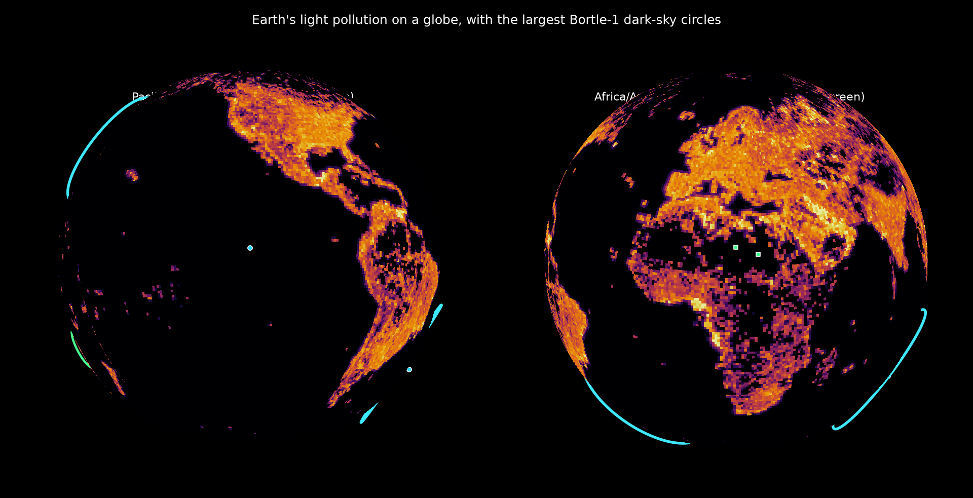
On a globe
The same circles, draped over the planet’s light-pollution texture. Drag to rotate — the cyan rings are the darkest circles (mostly ocean), the green ones are the accessible circles discussed below.
The answer
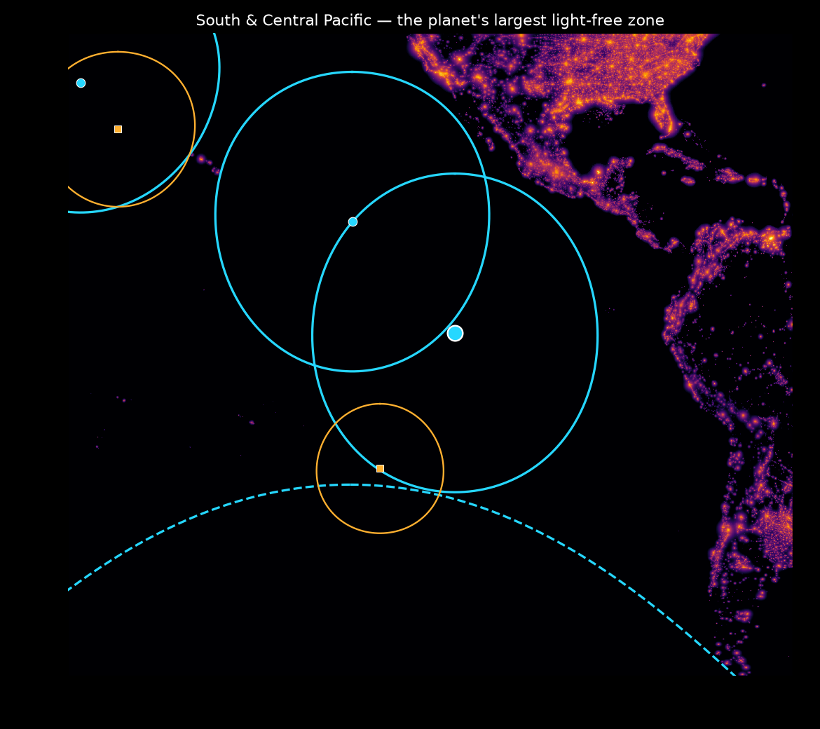
Unsurprisingly, the open ocean wins — the darkest, most light-remote places on Earth are in the middle of the great ocean basins, not on land.
The single largest fully-measured pristine-sky circle is centered in the equatorial South Pacific:
4.3°S, 115.9°W — radius ≈ 2,619 km. The nearest artificial light is 2,619 km away in the Marquesas Islands (French Polynesia).
You could place a circle 5,200 km across there and not enclose a single artificial photon. This result is remarkably stable — the radius stays within 2,615–2,620 km whether I set the Bortle-1 threshold at 0.5% or 5% of the natural background.
Top 5 circles by radius (global, ocean + land)
| # | Center (lat, lon) | Radius | Nearest light | Notes |
|---|---|---|---|---|
| 1 | 59.97°S, 133.28°W | 3,694 km | Austral Is. | Edge-limited — sits on the 60°S data boundary; true radius is even larger (see below) |
| 2 | 4.3°S, 115.9°W | 2,619 km | Marquesas Is. | Largest fully-measured circle (South Pacific) |
| 3 | 31.3°S, 84.7°E | 2,472 km | Rodrigues Is. | South Indian Ocean |
| 4 | 12.1°N, 132.9°W | 2,462 km | Hawai‘i | NE Pacific |
| 5 | 33.7°S, 18.6°W | 2,355 km | Brazil coast | South Atlantic |
The Antarctica caveat
The #1 circle lands exactly on the dataset’s 60°S southern edge. That’s an artifact: the Falchi atlas stops at 60°S, but everything beyond it — the Southern Ocean and Antarctica — is even darker. So its true radius is larger than measured, and the literal answer to “farthest from any artificial light” is somewhere in the Antarctic interior, trivially Bortle 1 and thousands of km from the nearest research-station lights. It just isn’t in this dataset. Among the fully-measured circles, the South Pacific is the honest winner.
Best dark skies on land
If you actually want to stand somewhere, the land winners are the world’s most remote islands:
| # | Place | Center (lat, lon) | Radius |
|---|---|---|---|
| 1 | Tristan da Cunha | 37.1°S, 12.3°W | 1,897 km |
| 2 | Île Amsterdam | 37.8°S, 77.6°E | 1,707 km |
| 3 | NW Hawaiian Is. (Kure/Midway) | 25.8°N, 171.7°W | 1,274 km |
| 4 | Line Islands (Kiribati) | 2.9°S, 171.6°W | 1,188 km |
| 5 | Pitcairn / Ducie | 24.4°S, 128.3°W | 1,064 km |
Dark skies you can actually get to
Remote islands and mid-ocean points are darkest, but you can’t exactly drive there. So I added an accessibility filter: keep only circles where there’s a mapped road within ~12 km of the center (so you can reach the sweet spot) and at least one airport inside the circle (so you can fly somewhere nearby). For roads I used the GRIP4 global road database (5 arc-min density raster); for airports, the OurAirports database (small/medium/large airports — note that any airport inside a pristine circle is necessarily a small, dim airstrip, since a big lit airport would itself break the darkness).
| # | Place | Center (lat, lon) | Radius | Nearest airport (inside) |
|---|---|---|---|---|
| 1 | Norfolk Island (Tasman Sea) | 29.0°S, 168.1°E | 703 km | Norfolk Is. Intl, 13 km — scheduled flights |
| 2 | Tanezrouft Basin, Sahara (Algeria/Mali) | 21.6°N, 6.2°W | 525 km | Chegga (Mauritania), 418 km |
| 3 | Tibesti, N. Chad | 21.8°N, 17.9°E | 450 km | Aozou airstrip, 93 km |
| 4 | Libyan Desert (Sudan/Chad/Libya) | 19.6°N, 25.0°E | 444 km | desert strip, 339 km |
| 5 | Zemio, S.E. Central African Rep. | 4.7°N, 24.8°E | 399 km | Zemio, 47 km |
Honorable mention: the Canning Stock Route in the Western Australian desert (22.7°S, 125.9°E, r ≈ 363 km), with the remote “Well 33” airstrip 120 km away — a genuinely reachable, world-class outback dark-sky site.
The clear practical winner is Norfolk Island: it has commercial flights, sealed roads, and the nearest light pollution is ~700 km away across the Tasman Sea. For a true continental trip, the central Sahara gives you a ~525 km-radius bubble of pristine sky.
Method notes
- Working grid: 0.05° (~5.5 km), max-pooled from the native 30″ raster.
- Bortle-1 threshold: artificial zenith brightness < 1% of the 174 µcd/m² natural background (≈ 0.00174 mcd/m²). Results are insensitive to this choice.
- Top circles are well-separated local maxima found by greedy great-circle non-maximum suppression (each new circle must lie outside the previously selected ones).
Data: light pollution — Falchi, F. et al., “The new world atlas of artificial night sky brightness,” Science Advances 2, e1600377 (2016), doi:10.1126/sciadv.1600377; dataset via GFZ Data Services, doi:10.5880/GFZ.1.4.2016.001 (CC BY-NC 4.0). Roads — Global Roads Inventory Project GRIP4 (Meijer et al. 2018, ODbL). Airports — OurAirports (public domain).